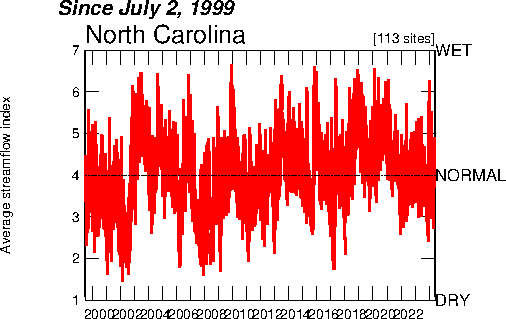
 An index value plot is a geovisualization map that plots the departures relative to a given index value. This index value plot measures the average streamflow index. The average streamflow index, plotted as the red line on the above graph, is calculated each day as the average of the streamflow index values for all the stream gaging stations in the state or water source region having at least 30 years of record. The streamflow index value at a station compares the real-time streamflow value to historical values for the day of the year.
Monday, July 14, 2008
INDEX VALUE PLOT
An index value plot is a geovisualization map that plots the departures relative to a given index value. This index value plot measures the average streamflow index. The average streamflow index, plotted as the red line on the above graph, is calculated each day as the average of the streamflow index values for all the stream gaging stations in the state or water source region having at least 30 years of record. The streamflow index value at a station compares the real-time streamflow value to historical values for the day of the year.
Subscribe to:
Post Comments (Atom)
No comments:
Post a Comment