Sunday, August 3, 2008

DLG (Digital Line Grap)

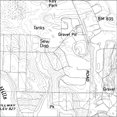
DLGs (Digital Line Graphs) are digital vector representations of topographic and planimetric map features derived from either aerial photographs or from cartographic source materials such as USGS maps ad related sources, using manual and automated digitizing methods.

This image is a Digital Line Graph (DLG) with raster text scanned from mylar separate. Separate feature layers allow for selection or omission of map features, and the vector data provides high quality line work for publication of geological maps.

CARTOGRAM

A cartogram is a map in which some thematic mapping variable – such as travel time or Gross National Product – is substituted for land area. The geometry or space of the map is distorted in order to convey the information of this alternate variable. There are two main types of cartograms: area and distance cartograms.

This is an image of the World economy cartogram. To highlight the distribution of wealth and power in the world of today, this cartogram sizes the countries according to their relative financial status, here presented through gross domestic product (gdp) per capita, offering an alternative world view to a regular map. Countries such as China and India become much smaller, next to giants in Western Europe, North America and Japan. Africa represents a minor speck, while South and Central America lands somewhere in between.

BATHYMETRIC MAP

A Bathymetric Map is a map that accurately depicts all of the various depths of a water body. A bathymetric map or chart usually shows floor relief or terrain as contour lines (called depth contours or isobaths), and may additionally provide surface navigational information. Color-coding to show the different depths of water is a common methodology used in bathymetric maps.

This image is a Bathymetric map of Lake Tahoe CA/NV. In this image, areas where the bottom is visible are colored red and green (greater bottom reflectance is shown in red). Where the lake is blue the bottom cannot be seen. The depth to which the bottom is visible varies depending on the clarity of the water.

Saturday, August 2, 2008

DEM (Digital Elevation Model) MAP

A digital elevation model (DEM) is a digital representation of ground surface topography or terrain. A DEM can be represented as a raster (a grid of squares) or as a triangular irregular network. DEMs are commonly built using remote sensing techniques, however, they may also be built from land surveying. DEMs are used often in geographic information systems, and are the most common basis for digitally-produced relief maps.

This image is a Digital elevation Model of the Hartnett Study Site. It displays the topography of the Hartnett study site in three dimensions. The model was created by digitizing a georeferenced DRG (Digital Raster Graphic) in Arcview GIS.

METES AND BOUNDS SURVEY MAP

The most well known unsystematic cadastral method for surveying land is metes and bounds. It is no longer practiced, but much of the US was initially surveyed in metes and bounds. Metes are units of distance and bounds (names of markers) are used to divide up land according to ownership. Since there is typically a strong reliance on landscape features, which could and often did change, move or no longer exist over time, this survey method was considered very problematic.

This image is an example of a Metes and Bounds Survey Map. The metes given are 45° southwest, 30 chains. A chain is a unit of measurement sixty-six feet long. There are eighty chains to the mile. The bound is the felled maple.

SYSTEMATIC PUBLIC LAND SURVEY SYSTEM

The Public Land Survey System (PLSS) is used to divide public domain lands, which are lands owned by the Federal government for the benefit of the citizens of the United States. The PLSS typically divides land into 6-mile-square townships, which is the level of information included in the National Atlas. Townships are subdivided into 36 one-mile- square sections. Sections can be further subdivided into quarter sections, quarter-quarter sections, or irregular government lots. Normally, a permanent monument, or marker, is placed at each section corner. The PLSS is a good example of a systematic land partitioning (cadastral) system. The reason this map is considered “systematic” is because the sections are divided using a systematic methodology.

This data for this systematic public land survey system shows the township, range, and sections for the majority of the state of Indiana, with a small gap in northeast Indiana.

CADASTRAL MAP

A cadastral map is a map showing the boundaries and ownership of land parcels. Some cadastral maps show additional details, such as survey district names, unique identifying numbers for parcels, certificate of title numbers, positions of existing structures, section and/or lot numbers and their respective areas, adjoining and adjacent street names, selected boundary dimensions and references to prior maps.

This particular Cadastral Map is an image of Agricultural fields near Campobasso – Italy.